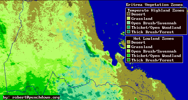
Within each agroclimatic, regime vegetation categories are divided according to productivity. Grasslands and deserts are fairly low productivity, while thick brush and forests are fairly high productivity areas.
The accompanying vegetation maps are produced assuming that vegetation zones are roughly correlated with remotely sensed vegetation indices, and temperature.
I have divided Eritrea into two temperature zones: A highland zone where the mean daily maximum temperature is less than 30 degrees Celcius, and a lowland zone where mean daily maximum temperatures are more than 30 degrees.
There are five vegetation classes for each temperature zone that are based on very rough estimates of mean annual vegetative productivity measured from NDVI images. Desert is defined as extremely low productivity (0 to 500 kilograms/hectare/year of primary biomass productivity). Grassland is low but significant productivity (500 to 1000 kg/ha/yr). Open bush and savannah is low to medium biomass productivity (1000 to 1700 kg/ha/yr). Open forest and brush is moderate annual biomass productivity (1700 to 2600 kg/ha/yr). And deciduous forest and thick deciduous brush is relatively high biomass productivity-- for Eritrea (more than 2600 kg/ha/yr).
You will note that by world standards, all of these numbers are low. But almost all vegitation zones in Eritrea are semi-arid with either annual plants or deciduous perennials which produce during a short rainy season of just a few months. So productivity throughout Eritrea is low.
The rough biomass estimates are produced by taking a set of mean monthly NDVI images, and comparing the average and the minimum of this set. They are compared with the minimum image in order to factor out geographic variations due to elevation, humidity, soil type, and rock type effects. Some few areas have some green vegetation all year. For those areas a fixed minimum NDVI corresponding to typical zero productivity levels was set (approximately an NDVI of 0).
A useful area of future research would be to more carefully correlate mean NDVI, temperature, and topographic features (such as mean slope and exposure) with surveyed vegetation classes, in order to produce a more accurate map verified with field data.
This information has been prepared by Robert Van Buskirk, Ph.D. If you have any questions regarding some of this research please feel free to email me at mailto:robert@punchdown.org. I enjoy both visting and working in Eritrea and am available for short-term consultations and technical training seminars.
Last update by rvb August 9, 1998.